Iceland Travel Guides
Eldfell: The Volcano That Entered Town in 1973
A fuller private guide to Eldfell on Heimaey, with the 1973 eruption, overnight evacuation, Eldheimar context, harbor change, lava-heated homes, and why this volcano feels personal.
GlaciGo Iceland / May 2026 / 10 min read
Eldfell is one of the rare Icelandic volcanoes that does not belong only to geology. It belongs to living memory. Most famous volcanoes in Iceland ask visitors to imagine deep time, ancient eruptions, or some saga-age world far beyond ordinary daily life. Eldfell is different. It rose in January 1973 on Heimaey at the edge of a real town whose people were asleep a few hours earlier. That nearness is what gives the mountain its unusual emotional force. You are not simply looking at a volcanic cone. You are looking at a place where a community had to wake up in the night, leave almost everything behind, and then decide whether the island could still be home.
Visit South Iceland gives the essential outline with admirable clarity. Its Eldfell page explains that the volcano was created in the eruption that began on 23 January 1973 and lasted for about six months. During that time, nearly one-third of the homes and buildings on Heimaey burned or were covered by lava and ash. That is already enough to keep the article from drifting into generic volcano language. Eldfell is not famous merely because it is beautiful to hike. It is famous because it appeared inside inhabited life.
The Eldheimar museum material deepens that human frame. The museum describes the 1973 eruption as one of Iceland's biggest natural disasters and explains that the people of Heimaey had to leave their homes in the middle of the night. Many never saw their homes or most of their belongings again. Its official English page adds the harder numbers and atmosphere: before the eruption, the population of Heimaey was around 5,300 people, and the entire population, apart from roughly 200 rescue workers, fled to the mainland while waiting anxiously to learn whether the island could still be lived on. That is the right emotional doorway into Eldfell. This is a volcanic landmark, yes, but it is also a mountain built out of evacuation, fear, improvisation, and return.
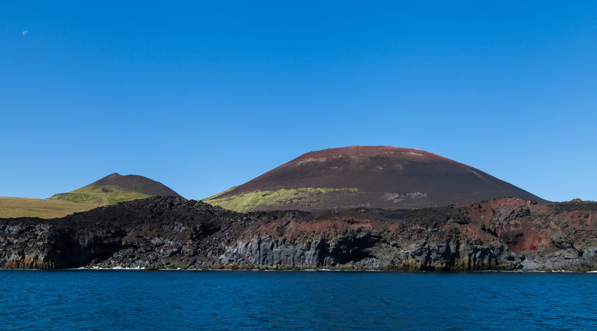
The official South Iceland volcano overview adds another important geological point. It explains that the Heimaey eruption began as a fissure eruption that opened at the edge of town and later became concentrated in a single crater, Eldfell. That transition matters because it helps visitors understand why the cone looks so legible today. Eldfell is not just a random hill beside the harbor. It is the concentrated final form of an eruption that began in a more open, unstable, urbanly terrifying way. The cone became a mountain, but it started as a crack in inhabited ground.
This is one reason Eldfell benefits from careful explanation rather than a few lines inside a Vestmannaeyjar guide. traveler questions here is layered in a very specific way. People want to know whether the hike is worth doing, what happened in 1973, how close the eruption came to the town, whether the volcano changed the harbor, and how best to connect Eldfell with Eldheimar. Those questions are not really separable. The hike only becomes meaningful if the history is inside it. Otherwise Eldfell risks being reduced to a pretty red-and-black cone with a viewpoint on top.
Visit South Iceland's Volcanic Way page offers exactly the kind of factual detail that makes the story feel lived rather than abstract. It notes that nearly 5,000 residents were evacuated overnight, that around 400 houses were buried under tephra and lava, that the eruption lasted more than five months, and that one person died from toxic gases. It also preserves one of the most striking ironies of the event: despite initial fear, the lava ultimately improved the harbor by giving it better shelter. That reversal belongs in the article because it captures something essential about Icelandic volcanic history. Destruction and adaptation are often intertwined. Eldfell damaged the town terribly, yet it also reshaped the island in ways the community later learned to use.
The same official material adds another detail that many visitors remember long after they leave: for around fifteen years after the eruption, hot lava was used to heat homes in town. That is such an Icelandic detail that it almost sounds invented, but it is precisely the sort of thing that keeps Eldfell from becoming a simple disaster narrative. The island did not only survive the eruption. It found a way to live with what the eruption had left behind. The new mountain and lava were not just scars. They became part of the town's practical future.
Visually, Eldfell is compelling because it still looks young. The slopes retain a rawness that older volcanic landscapes often lose. The reddish and dark surfaces, the loose tephra, the sense of a cone that has not yet had centuries to soften into background topography, all make the hike feel unusually direct. This is part of why climbing Eldfell works so well for travelers who want geology to feel immediate. You are not deciphering a mostly-eroded memory. You are walking on a form that still looks recognizably new.
But the hike is most powerful when paired with the town below. From above, Heimaey makes emotional sense in a way it cannot from a museum room alone. You see the harbor, the built edge, the surrounding sea, Helgafell nearby, the lava fields where streets once continued, and the compactness that made the 1973 event so intimate and so frightening. A private traveler with the right pacing can do Eldheimar first and Eldfell after, and that order is ideal. The museum gives names, homes, and faces to the eruption. The hike then restores scale.
This also gives Eldfell a different personality from volcanoes like Fagradalsfjall or Hekla. Those often ask to be read as active geological systems or spectacular eruption landscapes. Eldfell is more civic. It belongs to an island-town story. Even when you are looking at ash, crater, and lava, your imagination keeps returning to houses, harbor walls, fishing life, and the speed with which ordinary routines were interrupted. The mountain never quite escapes the town, and that is exactly what makes it memorable.
Photographically, Eldfell is stronger than many people expect because it offers more than one grammar. From below, it can be read as a sharply defined cone looming above Heimaey. From the slope, it becomes a texture story of ash, scoria, wind, and trail. From the top, it shifts into a whole-island composition where the cone is only one element inside the broader relationship between town, sea, and volcanic ground. The best images usually do not isolate the crater too aggressively. They let the viewer understand that the volcano exists in close argument with the settlement.
There is a moral intelligence in the place too. Eldfell is not a monument to untouched wilderness. It is a reminder that Icelandic nature is not always comfortably distant from where people live. That realization can be good for travelers. It complicates the usual postcard idea of Iceland as a series of scenic stops outside human life. On Heimaey, volcano and town are interwoven. Nature did not perform for visitors here. It broke into a community, and the community had to answer.
At the same time, Eldfell does not leave most visitors only with dread. The atmosphere today is surprisingly mixed: sober, yes, but also lucid and strangely hopeful. The path to the top is one of the most popular hikes on Heimaey for a reason. People do not climb it only to relive catastrophe. They climb it because the volcano has become part of the island's self-understanding. Eldfell now belongs to the visible shape of home. That transformation from rupture to identity is one of the deepest stories in South Iceland.
Eldfell benefits from a fuller explanation because too much writing about it stops at the phrase volcano created in 1973. What matters on the ground is the fuller combination: fissure-to-crater formation, overnight evacuation, buried homes, Eldheimar as interpretive key, improved harbor, lava-heated houses, and the reason the hike feels different from other volcano walks in Iceland. The stronger answer is that Eldfell is one of the country's clearest examples of a volcano that is simultaneously geological, historical, civic, and personal.
What stays with many travelers after Eldfell is usually not the crater alone, but the altered relationship between mountain and town. You come expecting a volcano hike. You leave understanding that this hill was born in the lifetime of people still remembered by name, that the ash and lava changed the plan of the island, and that the view from the summit is really a view into how a community survives an eruption without pretending it was small. Eldfell lingers because it is not only dramatic. It is deeply inhabited.