Iceland Travel Guides
Hverir: Steam, Sulfur, and the Exposed Surface of North Iceland
A fuller private guide to Hverir, with its mud pots and steam fields at the foot of Námafjall, its place within the Mývatn volcanic district, and the reason it feels less like a viewpoint than a living process.
GlaciGo Iceland / May 2026 / 10 min read
Hverir is one of the few places in Iceland where the ground seems to have given up any interest in behaving like ordinary earth. The colors are wrong for pasture, the texture is wrong for comfort, the air smells insistently mineral, and the whole surface appears to steam, bubble, crack, and stain itself in shades that make many visitors reach for the easiest comparison available: Mars. The comparison is understandable, but it is also slightly lazy. Hverir is more interesting than another-planet spectacle. It is a place where North Iceland's volcanic restlessness becomes so immediate that the land stops being scenic background and starts acting like a process.
The official Visit Mývatn material places Hverir, also called Hverarönd, at the foot of Námafjall in the Mývatn area. That position matters. Hverir is not a freestanding geothermal curiosity detached from its surroundings. It belongs to a larger volcanic district that includes Krafla, Hverfjall, lava fields, caves, and the living wetland complexity of Mývatn itself. What makes the site so compelling is precisely this juxtaposition: only a short distance from duck-rich water and delicate ecological balance, the ground here looks chemically exhausted, overheated, and almost stripped back to the raw grammar of the earth.
This contrast is one of the most important things to preserve in the article, because it keeps Hverir from turning into a generic geothermal stop. Near Mývatn, life can seem abundant and soft: shallow water, reeds, birds, countless inlets. At Hverir, softness disappears. Steam vents hiss from the soil, mud pots bubble, and mineral colors gather in streaks of ochre, red, grey, white, and sulfur-yellow. The district does not ask you to choose between ecological richness and volcanic severity. It insists that both belong to the same landscape.
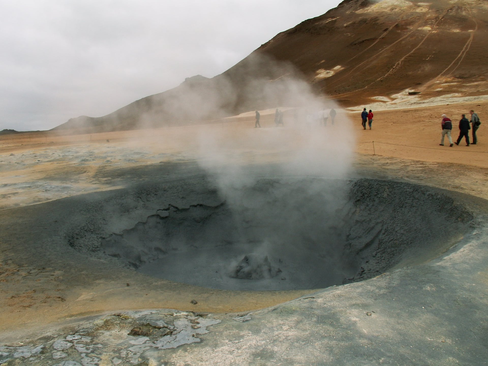
Visit North Iceland describes Námafjall and the hot springs at its foot as known for their variety, and that word is useful. Hverir is not impressive because it shows one perfectly shaped geothermal feature. It is impressive because so many unstable states of matter seem to coexist in a relatively compact area. Mud thickens and bursts. Steam rises from cracks. Mineral crusts form and discolor the ground. Nothing feels fully settled. Even the paths, though carefully laid out for protection and access, lead through a place whose primary visual message is that the earth beneath them is still active, hot, and chemically busy.
That active quality gives Hverir a very different emotional tone from other geothermal sites in Iceland. Seltún in Reykjanes carries a stronger sense of boardwalk interpretation within a broader lava-and-lake landscape. Hverir feels harsher and more exposed. The colors are starker, the forms less ornamental, and the whole place seems less like a designed viewpoint and more like a tolerated edge of instability. It is one of those sites where the visitor is not invited to relax into the scene so much as to witness it.
The name Hverarönd itself helps. It points to the edge of the hot springs rather than to a single object. That is fitting, because Hverir is experienced as a field condition rather than a focal monument. You do not arrive, take in one central feature, and understand the place. You move through it, noticing one mud pool after another, the changing sound of vents, the shifts in color, and the slight unease of being in a landscape that looks unfinished in the best possible sense.
Námafjall above the site deepens the experience further. Visit Mývatn's hiking route framing makes clear that Hverir belongs to a larger movement up and around the mountain, not merely to a parking-lot stop. That matters because the geothermal field is strongest when understood as part of a vertical landscape: the steaming ground below, the mountain rising behind, the wider Mývatn district nearby, and Krafla's volcanic history not far off. Hverir is a local concentration of much bigger forces. The mountain gives the site a stern backdrop, but also a sense of context.
The Mývatn Fires belong quietly in the background here as well. Even when a visitor does not bring detailed geological knowledge to Hverir, the district's recent volcanic history still shapes the emotional reading of the place. In the Mývatn area, eruption is not an abstract prehistoric event. It belongs to remembered centuries and traceable features. That changes how Hverir feels. The steam and mud do not seem like static curiosities. They feel like the continuing surface conversation of a volcanic system that has not finished speaking.
For tourists, one of Hverir's strongest qualities is how quickly it clarifies the idea of Iceland as a geothermal country. In many parts of Iceland, geothermal energy is mostly encountered through comfort: hot water in houses, pools, baths, greenhouses, and warm interiors. Hverir shows the less domesticated side of the same reality. This is geothermal Iceland before it is piped, softened, or made useful for everyday life. It is heat still arriving in the landscape as smell, stain, vapor, and heat underfoot.
That is one reason Hverir is particularly memorable on a private itinerary. It changes the rhythm of a day. If you arrive from Mývatn's calmer waters or from Goðafoss and the broader route through the north, Hverir feels like a sudden stripping away of softness. The day becomes more elemental. Travelers often become quieter there, not because the place is peaceful in the usual sense, but because it demands a different kind of attention. You stop looking for prettiness and start looking for signs of activity.
Photographically, Hverir offers a vocabulary unlike almost anywhere else in Iceland. Steam columns, bubbling mud, mineral edges, footprints on dark paths, and the rise of Námafjall all make strong images, especially when weather adds low cloud or side light. But the best photographs are usually the ones that preserve some sense of scale and instability rather than isolating one bright mud pot as if it were a decorative object. Hverir is most truthful when it looks like a field of conditions, not a single attraction.
The site also benefits from being approached with respect rather than overconfidence. Even without turning the article into a safety sheet, it matters to imply what the maintained paths already express: this is not casual ground. The beauty here depends on heat, chemistry, and fragility. Visitors do best when they move carefully, stay on the designated routes, and let the strangeness of the place remain strange instead of trying to dominate it through closeness. Hverir is a good reminder that some Icelandic landscapes are best experienced through disciplined curiosity.
Hverir benefits from clarity because travelers encounter several names around the same landscape: Hverir, Hverarond, Namaskard, and Namafjall. The site is easily reduced to a fast photo stop near Myvatn, but it is more useful than that. Hverir shows the Myvatn region becoming chemically visible: steam, sulfur, clay, heat, warning signs, and mineral color all concentrated into one exposed surface.
What stays with many visitors after Hverir is not one single shape, but a sensory memory: the smell of sulfur, the hiss of steam, the thickness of the mud, the mountain looming above, and the unsettling pleasure of seeing the earth behave in ways that seem only half compatible with ordinary life. Hverir lingers because it is not merely dramatic. It feels exposed, active, and uncompromising. In a country full of beautiful surfaces, it is one of the places where the surface itself starts to look alive.