Iceland Travel Guides
Mælifell: One Green Cone Against the Black Sands
A fuller private guide to Mælifell, with its isolated cone shape, black-sand setting, Fjallabak context, Highland access reality, and the precise visual drama that makes it unforgettable.
GlaciGo Iceland / May 2026 / 10 min read
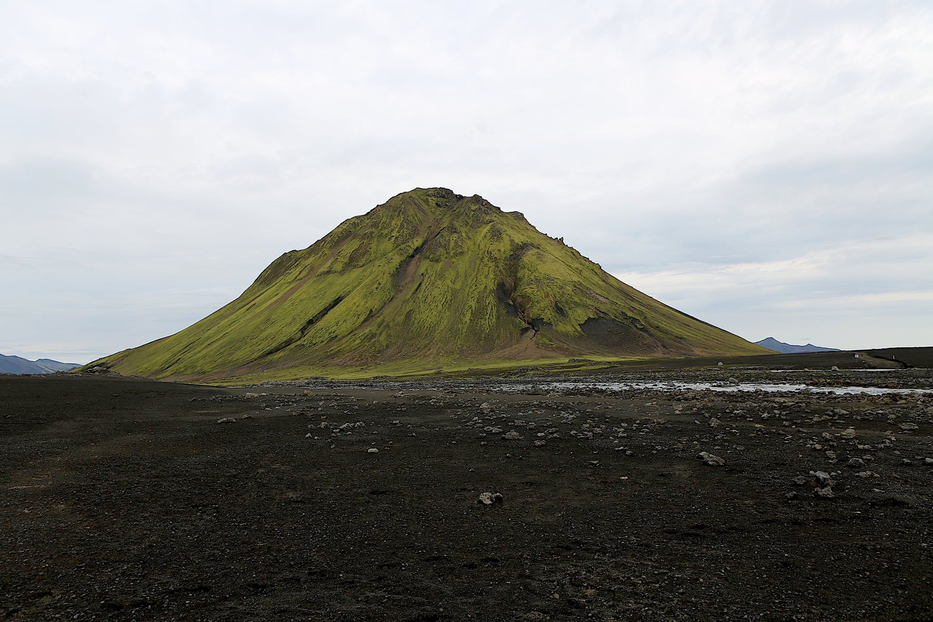
Mælifell is one of those Icelandic mountains that can feel less like topography and more like an idea. A near-perfect green cone rising from black sand plains, isolated enough that it often looks detached from ordinary scale, framed by weather that can make it appear either precise and photographic or almost mythic. People who have not seen it in person often assume the images must be overworked. People who have seen it usually remember not only the shape, but the strange quiet confidence with which the mountain holds its place in the southern Highlands.
The first thing worth establishing carefully is that this is the Mælifell of the Emstrur and Mýrdalsjökull region, not one of Iceland's other mountains with the same name. Wikimedia's structured description identifies it as a mountain and volcano in Rangárþing ytra, Suðurland, with an elevation of 791 meters. That clarity matters because Mælifell's identity depends so much on context. It is not merely a cone-shaped mountain somewhere in Iceland. It is the cone-shaped mountain that rises from Mælifellssandur in the black-sand world south of Mýrdalsjökull.
Visit South Iceland does not give it a long standalone page, but the references it does provide are revealing. Katlatrack's official listing under South Iceland includes Mælifell among its Highland super-jeep destinations, placing it explicitly within a world of black sand plains, mountain roads, and guide-led interior access. That is the right atmosphere. Mælifell is not a stop that belongs to easy lowland tourism. It belongs to the rougher grammar of interior travel, where the road itself starts shaping the mood before the destination fully appears.
The same South Iceland ecosystem adds another useful glimpse through the Chris Burkard Volcanic Way article, which calls visiting Mælifell one of the highlights of exploring the Highlands and notes the views there as incredible. That wording may sound broad, but it points toward something real. Mælifell is not primarily about hiking difficulty or a checklist of nearby services. It is about visual impact inside a much larger volcanic and glacial environment. The mountain works because it seems almost too clean a form for the landscape that surrounds it.
Fjallabak's official geological context helps explain why. Umhverfisstofnun's description of nature and geology in the reserve explains that the region was formed on the western rift zone and contains extraordinary volcanic formations shaped over millions of years, including rhyolite mountains and other products of repeated eruptions under changing conditions. Mælifell is not rhyolite in the way Landmannalaugar's surrounding peaks are famous for, but it belongs to the same larger lesson: the southern Highlands are not random wilderness. They are a highly articulated volcanic landscape where singular forms emerge from a complex geologic history.
What makes Mælifell feel so singular is the contrast between form and setting. The cone itself is famously steep and visually self-contained, while Mælifellssandur around it feels open, dark, and almost stripped of distraction. The black sand plain does a great deal of aesthetic work. Without it, the mountain would still be elegant. With it, it becomes almost iconic. The cone appears greener, cleaner, and more improbable because the surrounding world is so muted and ash-dark. This is one of Iceland's most powerful examples of a landscape achieving visual force through subtraction.
That green cover matters too. Moss and low vegetation soften the mountain just enough to keep it from looking purely hostile. The result is one of the great paradoxes of Highland Iceland: a volcano that feels both stark and almost tender from a distance. Mælifell can look severe under cloud and yet strangely delicate under soft light. It is a mountain that changes not only with weather, but with the emotional state the weather creates in the viewer.
The route context deepens the effect. Mælifell is often associated with journeys through the southern Highlands that also involve river crossings, black sands, glacial margins, and views toward Mýrdalsjökull. This means the mountain is rarely experienced as an isolated roadside object. It appears as a reward inside a broader movement through difficult ground. That matters because the image of Mælifell has become famous enough to risk flattening it into a symbol. In reality, the symbol lands properly only when the surrounding terrain has already taught your body something about remoteness.
Photographically, Mælifell may be one of the most immediately recognizable mountains in Iceland, but it is also one of the easiest to simplify too much. The obvious image is the cone centered against black ground and moody sky. It is a strong image for a reason. But the deeper visual story often includes more of the surrounding sandur, the relationship to weather, or the presence of tracks, rivers, or glacial edges that help explain where the mountain actually lives. Mælifell is not a studio object. It belongs to a moving volcanic system of sand, water, ice, and cloud.
This is one reason the mountain can feel nearly surreal without becoming fake. The geometry is real. The black plain is real. The weather theatrics are real. But because the combination is so exact, the place briefly loosens your trust in what a landscape is allowed to look like. Good travel writing should not cheapen that by pretending Mælifell is literally unreal. It is better to say that it is one of the rare Icelandic mountains that makes reality itself seem more stylized than expected.
Compared with Bláhylur, Mælifell is less about a contained color event and more about isolated form. Compared with Kerlingarfjöll, it is less distributed and more singular, less about a whole mountain world than about one unforgettable peak within a severe setting. Compared with Eldfell, it is far less civic and historical in the lived-community sense, and much more about shape, sand, and remoteness. These differences matter because they keep Mælifell from being reduced to a generic volcano article. Its strength is not activity, legend, or access. Its strength is presence.
There is also a healthy restraint in how the place should be visited and described. South Iceland's own structure of guided Highland offerings, and the broader protected-area culture of the region, both imply something important: Mælifell is best understood through conditions, timing, and access reality, not through romantic spontaneity. The mountain can look temptingly simple in photographs. The actual route environment is not simple. That gap between image and approach is part of the truth of the place and should remain visible in the article.
Maelifell benefits from careful explanation because traveler questions around it is both specific and emotionally charged. People are not only asking where the cone mountain in the black sands is. They are asking whether it is really as striking as it looks, whether it is worth the effort of a Highland route, and what gives it such an unusual visual identity. The strongest way to understand it is that Maelifell is one of the purest landscape forms in Iceland: a solitary green cone made more powerful by the black emptiness around it.
What stays with many travelers after Mælifell is not simply the memory of a mountain, but the memory of proportion. One cone. One black plain. One difficult road world. One moment in which the southern Highlands seemed to strip themselves down to the essentials of shape and color. Mælifell lingers because it does so much with so little. It proves that in Iceland, one mountain can feel like an entire thought.